

Sailing to the Search Area [S2Ep44 video]
Armada 86 05 has left port and is now 11 days out from the presumed crash site

It’s December 7, 2025, and Armada 86 05 has set sail from Benoa Port on the island of Bali, Indonesia. After spending a brief period conducting sea trials, it is now making a beeline for the area where it left off searching the seabed in March. If it maintains its current speed, it should arrive a day or two before the date previously given by the Malaysian government as the start of the new phase. In today’s episode, we discuss the capabilities as well as the limitation of the technology that Ocean Infinity will deploy once it arrives.
To recap: in the last episode, we talked about how the ship that everyone suspected was going to be tasked with looking for the plane, Armada 86 05, had been working on a project in the Philippines looking for historical shipwrecks.
It wrapped up that job on December 3, docked at the port of Legazpi in southern Luzon for refuelling and resupply. From there it headed south on December 6, threading its way through the islands en route to Bali, Indonesia, where it arrived December 14.
It spent less than 24 hours in port there, implying that it didn’t do a further full resupply but probably just took on a key member of the crew or perhaps some crucial pieces of equipment, and then headed out for sea.
But it didn’t get very far. On December 16, when still only about 200 nautical miles offshore, it stopped and then began moving in a manner characteristic of launching AUVs. Now, to be clear, there is nothing particularly of interest in this area. But we’ve seen this behavior before. As Kevin Rupp pointed out in a recent Tweet, we saw this exact thing after the ship that conducted the last phase of the search Armada 78 06, left port in Mauritius on its way to carry out the search this past March.
I think it’s reasonable to assume that the crew wants to be absolutely sure that everything is in good working order before they sail thousands of miles out into the middle of the empty ocean. Once you’re out there, if you realize you left your only screwdriver back in port you’ve got a big problem on your hands.
Earlier today Kevin Rupp reported that the ship has started moving again. According to Big Ocean Data the ship is moving on a heading of 210 degrees at around 7 knots. That’s pretty much a beeline for the area where they left off searching in March. It’s a distance of 1800 nautical miles, so 258 hours or just under 11 days. Assuming they keep at it, they’ll arrive on the 28th, so actually a bit early for the announced resumption of the search on December 30.
OK, we’ve talked in previous episodes about where exactly on the seabed they’re likely to scan, today I want to discuss what exactly they’re going to do when they arrive on station.
The technology that they’re going to use is the Hugin 6000 Autonomous underwater vehicle, or AUV, a robot sub that can dive to a depth of 6000 meters or 3.7 miles. The Armada 86 series of ships is a state-of-the-art technology that is designed to work very efficiently and can even operate without a human crew, but it is not really optimize for working with AUVs.
Unlike the ship that carried out the original Ocean Infinity search in 2018, it doesn’t have dedicated equipment for launching and retrieving AUVs. Instead it has detachable garages called containerized sheds that go on the back of the ship. Three of these have been attached to A86 05.
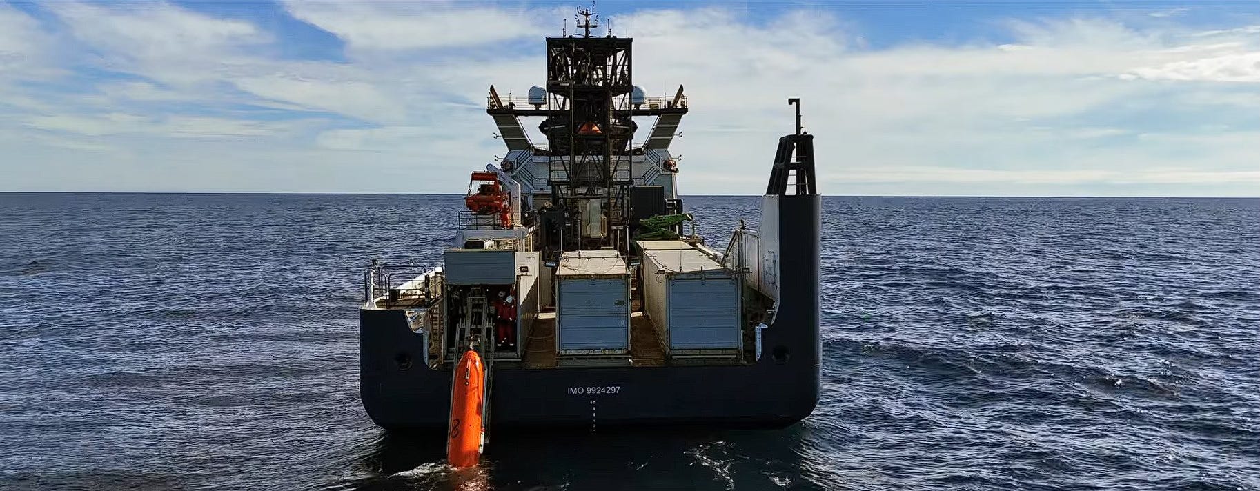
There are three sheds, to house the three AUVs, and even though these all look the same they have different technology. To quote Don Thompson, who’s been following developments closely:
I am quite confident to state that one of the Hugin AUVs is equipped with a Kongsberg HiSAS system while the other two AUVs will use Edgetech (real aperture) side scan sonar. The HiSAS provides higher & consistent resolution across its swath but the swath width is maybe only 25% of the Edgetech in SAS mode.
These AUVs can operate up to up to 50 hours before they have to return to the surface, where a detachable nose cone comes off, it’s connected to the main body with a cable, the crew on board the ship either throws a grappling hook or shoots it out of a compressed-air gun, the trick is to snag that cable so that the AUV can then be hauled nose-first onto what’s called a stinger, basically a retractable ramp, and raised into the shed where a cable can be attached to download the data.
So what if they find the wreckage? That will be exciting, but the mystery won’t be solved yet. In order to figure out exactly what happened to the plane, investigators will have to retrieve the black boxes. And that’s not something that the search vessel has the cabability to do.
The AUVs it deploys can look, but they can’t touch. To actually get in there and grapple with the debris, investigators will have to deploy an ROV, or remotely operated vehicle, that has lights and cameras and claws and so forth. And A86 05 doesn’t have any ROVs. Here’s Don Thompson again:
The Armada fleet has only two deep ocean capable ROVs and both continue to be used in UK North Sea projects (A78-01, TotalEnergies offshore asset inspections, and A78-06, gas pipeline inspections of Bacton, Norfolk).
So what this means is that in the event that they do spot wreckage that looks like MH370, there will definitely be celebration, but also a lot of anxious anticipation as Ocean Infinity decides how it’s going to reposition its assets in order to get the job done.
Right now, we’re about two weeks out from the start of the seabed scan. In the meantime I wanted to wrap up by bringing something else to your attention.
Earlier this month a Chinese state television channel reported that a Chinese court ahd ordered Malaysia Airlines to pay $3.3 million in compensation to family members of eight missing passengers. The report said that another 47 cases have been settled and withdrawn, and 23 cases remain underway.
A reminder that the disappearance of MH370 is not ancient history, this is a story that is still developing and still affecting people today. The human suffering continues.
Why are they not looking by the Nicobar Islands? Why is there no demand from military asset satelite data from the US as just one country who has the information and data from that time? Sat. are and were constantly monitoring the skies, land and seas. There is data on that planes flight and disappearance. Someone (gov.) knows and has that data.