

New Search: Week 3 [S2Ep48 video]
It's summertime in the southern ocean, but the weather isn't playing nice. Plus: accident investigation insights from NASA

Last week we expected that the scan of the seabed was about to take a short-term break, as Ocean Infinity’s research ship, Armada 86 05, was scheduled to return to port the very next day. Well, right after that episode dropped Ocean Infinity changed its plans: its arrival data in Fremantle was switched from January 20 to January 29. This was definitely a welcome development; it’s always a good thing if Ocean Infinity spends more time than expected scanning the seabed. But unfortunately, the weather did not play along. A storm hit the area, forcing Armada 86 05 to retrieve the AUVs and wait out the strong winds and massive waves.
Usually we have to deduce this kind of thing from the movement of the ship on marine tracking websites, but on Monday the Malaysian government took the unusual step of releasing an update, basically summarizing what Ocean Infinity had been up to. The statement was posted by MH370 Families on their Facebook page:
Between 06 and 15 January 2026, search operations onboard Armada 8605 were conducted in the designated search area on the southern side of the 7th arc, primarily utilising up to 3 x Hugin Autonomous Underwater Vehicles (AUVs). Operations resumed on 06 January following prior activities and proceeded steadily through the reporting period, subject to technical and environmental conditions.
From 06 to 14 January, search activities were largely uninterrupted. The AUVs were deployed on planned missions, regularly monitored by the vessel and recovered as required, for data download, battery replacement and preparation for subsequent launches. A brief technical issue on 07 January required the early recovery of one AUV; however, this did not significantly impact overall progress and full three-AUV operations resumed thereafter. Intermittent handshakes were observed during several missions but did not impede data acquisition or mission continuity.”
On 12 January, all 3 x AUVs completed their respective missions and were sequentially recovered to enable data handling and redeployment, ensuring continuity of survey coverage. Weather conditions remained favorable for operations until 14 January, allowing sustained surveying efforts. On 15 January 2026, search operations were halted due to inclement weather, and all 3 x Hugin AUVs were safely recovered onboard Armada 8605. Operations are planned to resume once conditions improve and it is deemed safe to do so.
Last week’s episode dropped on Tuesday, January 13. That means that they had only another day and a bit to search before the bad weather came in, to they made very little progress. At the end, you see the squiggly red track on the upper right, that means they’re moving slowly as they wander from the search area.
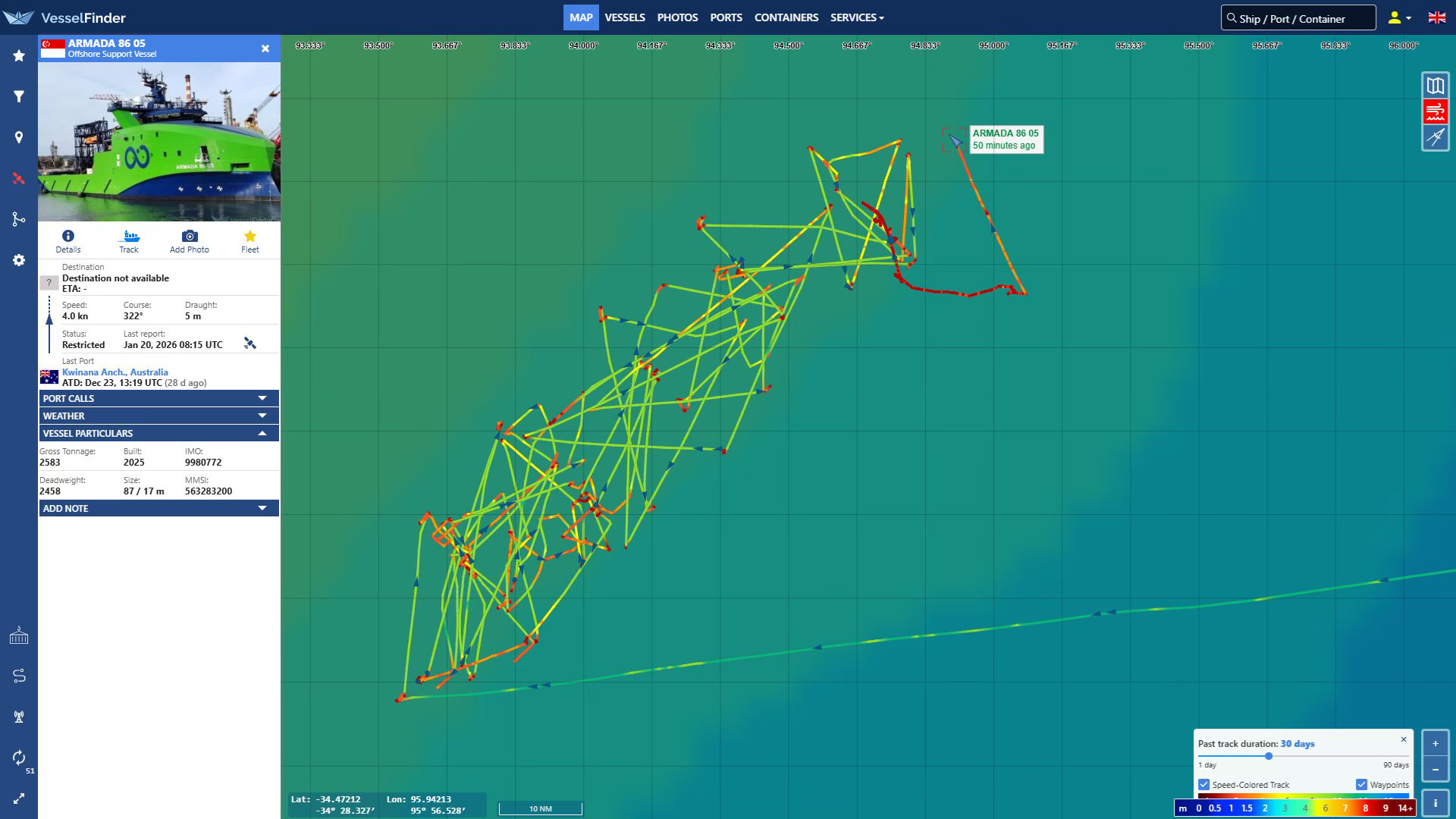
The ship is probably just trying to keep the bow pointing into the waves and trying to endure the ups and downs of the waves as best ity can. The folks aboard that ship are probably not having a lot of fun out there right now. Kevin Rupp reports on Twitter that they’ve had to deal with waves as high as 5.7 meters, or 18.7 feet.
So what lies ahead? The current plan is for Armada 86 05 to leave the search area on the 24th, local time (i.e., three days from now) in order to get into port at Fremantle on the 29th.
Kevin says that the weather is not looking good for the continuation of the seabed scan between now and then. He wrote on Twitter earlier today, “After a brief respite, conditions are about to get pretty rough for Armada 86 05 again…I still don’t know why they didn’t run for Fremantle.”
If he’s right, it’s unlikely they’ll get any more scanning done on this phase of the search. That extra week that they added will turn out to have been a long walk for a short drink.
Another interesting tidbit from the Malaysian report is this table showing the amount of seabed scanned in recent days:
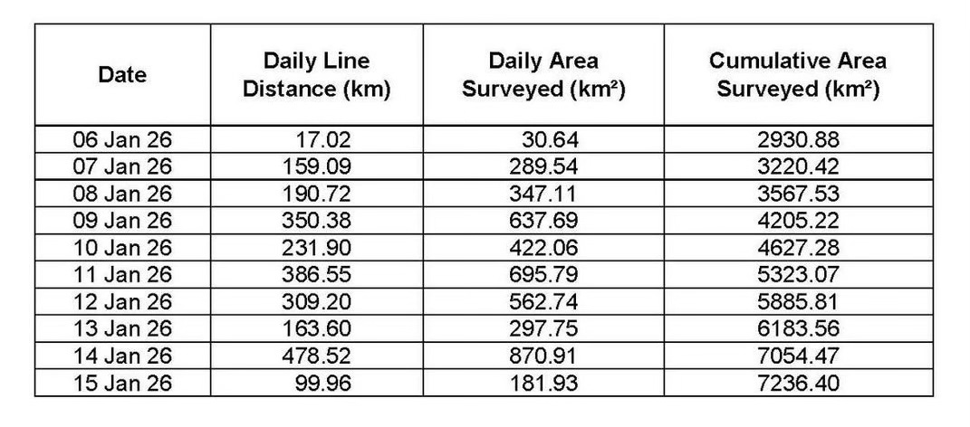
Between January 6th and 15th the AUVs were deployed for 10 days and they scanned between 30 and 870 square kilometers per day. In total they added 4,336 square kilometers to the previous total of 2900 square kilometers for a total of 7,236 square kilometers. That’s just shy of halfway to the 15,000 square kilometers Ocean Infinity has said it plans to search.
Viewer @glenn354023 made in interesting observation. In the second column of the table you can see the “daily line distance” that the AUVs carried out each day. That presumably means how far the AUVs traveled over the seabed as they sent out their sidescan sonar beams. Well, if you divide that figure into the total area searched that day, you get the width of the area scanned.
Glenn writes: “By this math they are saying that they are covering 1.8km in a single pass (900m per side of the vehicle). The stated range of the HiSAS is 260m max. How are they outperforming the specs of the equipment by a factor of 3? It’s a valid question to be asked.”
That is interesting. Maybe it’s that the line range is how far each of the AUVs traveled, not all of them collectively, so that’s why they’re multiplying by three? Or do they have some new technology that lets that scan three times further? I think the former is more likely than the latter but if anyone has some insight from the company, please do let me know.
For the rest of the episode I’m delighted to be joined by a very esteemed guest, Dr Nigel Packham, who spent decades at NASA studying safety and risk in manned spaceflight and was involved in the investigation into the Space Shuttle Columbia disaster. NASA spared no expense to make sure that it understood what had caused the deaths of seven astronauts and the destruction of the space vehicle, and I think MH370 deserves to be treated with the same degree of seriousness. Dr Packham was generous in sharing his expertise in conducting a successful investigation. One tip that has stuck with me in particular was his advice about what to do when you’ve exhausted all the possibilities you can think of and still can’t find the answer: “Just keep going.”
Hi Ilya, those are all good questions, but we can only work with the evidence at hand.
Jeff - Your podcast is excellent. As a project manager and space nerd, I really appreciated the insights of your guest speaker. One thing struck me—he said that the view of the leading edge of the left wing was obscured by the cargo bay doors. Could the astronauts have seen the wing if the doors were temporarily closed? Seems that would have been doable even if NASA chose not to deploy military assets to image the orbiter.