

Into the Blelly Zone [S2Ep33 video]
As Phase 2 of the seabed search for MH370 continues, a major hypothesis is put to the test

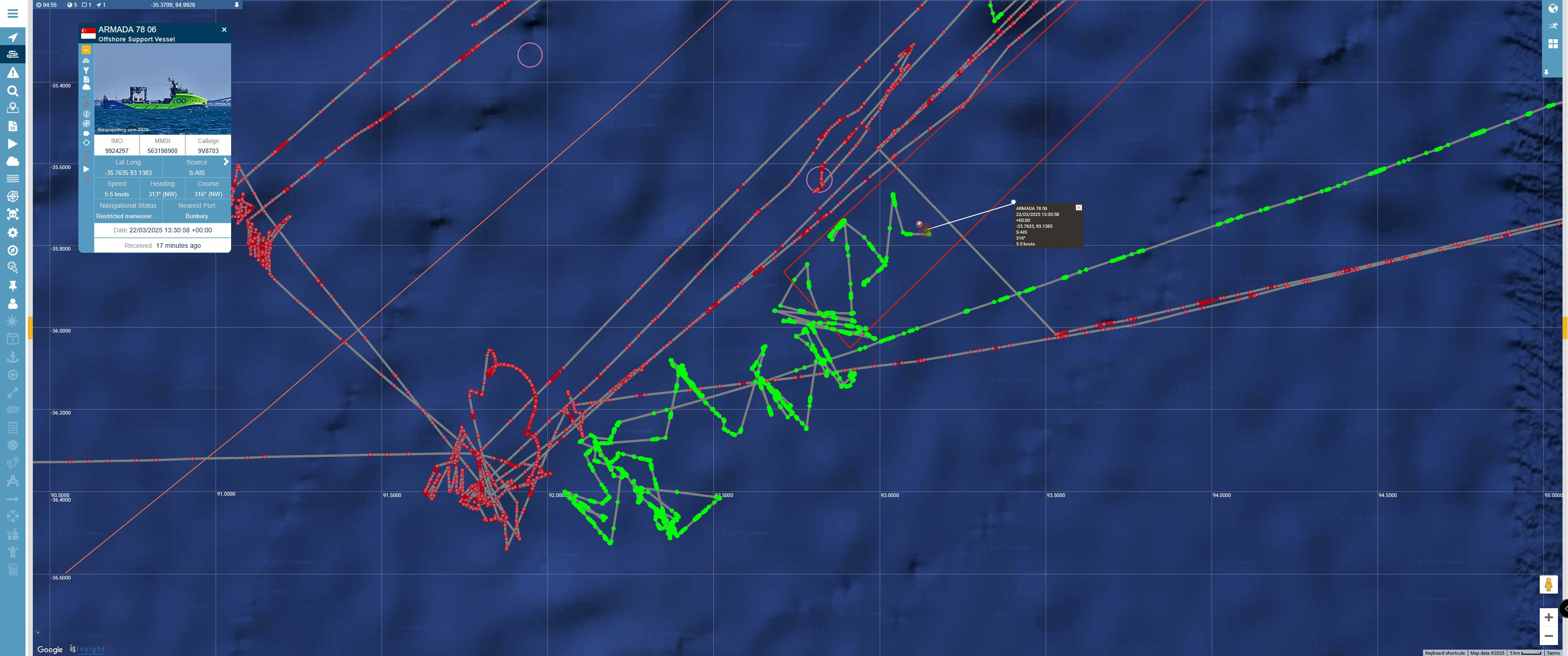
The seabed search for MH370 remains in full swing, with Phase 2 of the third seabed search currently in its 12th day. In the last episode, which I posted a week ago, Armada 7806 had just returned to scanning the seabed after taking a break to resupply near Perth, Australia. At the time, it seemed to me that the ship and its AUVs had begun working a strip of seabed, with the undersea drones working back and forth over the seabed, imaging the ocean floor like lawnmowers mowing a lawn. This is an orderly way of searching, it’s quite different from what they were doing in Phase 1, which was filling in gaps, so more like filling potholes in a road by going from spot to spot to spot.
But while this is very regular behavior, we can’t see it. We can only assume that that’s what they’re doing based on the movent of the ship on the surface. As we can see the image below, the track of Armada 78 06 (in green; the red track is that of the search ship that carried out the 2018 search) is not particularly orderly at all. It’s zigzagging all over the place as it goes back and forth collecting and redeploying AUVs.
The fact that Ocean Infinity searched data gaps in Phase 1, and are now searching a strip far beyond the 7th arc, seems to me to settle a longstanding mystery: what was the reasoning behind Ocean Infinity’s decision to undertake this third seabed search? It now seems clear that this latest effort was motivated by the analysis that Victor Ianello and his colleagues published back in 2023.
Here’s a map that accompanied that analysis. Zone 1 is that inner area that had already been searched, with the data gaps. Zone 2 is the new territory that they’re now searching.

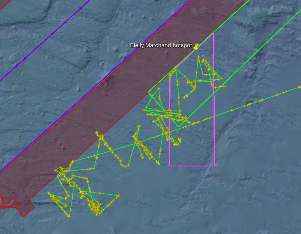
Here’s a modified version of the map that Victor published more recently. Here his proposed search area is in red. I’ve overlain it with the bright-green track of Armada 78 06 in the current phase of the search:

As you can see, the dimensions of the strip they’re searching are very similar to what Victor proposed, but started further south and they’re covering an area that extends a little further away from the 7th arc, about 55 nautical miles rather than 50 nautical miles.
There are various spots in this general area that have been singled out by independent researchers as being particularly likely endpoints for MH370. One that’s gotten particular attention is the hotspot nominated by Jean-Luc Marchand and Patrick Blelly, shown below. Armada 78 06 is right in the thick of it right now, in fact I think they’ve searched most of it at this point. I imagine Mssrs Marchand and Blelly are on the edge of their seats.
How quickly the current search is covering the seabed? We can’t tell with any accuracy, given that all we can see is the motion of the ship on the surface, but if we compare the area the ship has been working over from last weekend to this one, we see that they’ve gone from about 1000 sq km to about 5200 sq km, meaning they’ve covered about 4000 sq km in a week. If they do Victor’s red rectangles they’re definitely going to go significantly over 15000 sq km, which wouldn’t surprise me.
Interestingly, Ocean Infinity’s 2018 search covered 120,000 sq km in about four months (as I recall), so about 30,000 sq km per month or 7,000 sq km per week. I had hoped that technology might have improved in the interim so that the current search would proceed faster, but that seems not to be the case. Worth noting that Armada 78 06 is smaller than the ship used in 2018 and carries fewer AUVs.
A much-pondered question at the moment is how long the ship will keep going on its current swing. A reasonable assumption is that Armada 78 06 has to go back to port every month to swap out the crew, but we don’t really know that for sure. One thing we’ve learned in the last few weeks is that we can’t trust the destination and ETA that’s displayed in marine tracking. So we’ll just have to wait and see. Kevin Rupp is saying that in order to get back to Freemantle for the one-month switchover they’ll have to leave the search area on March 28. If they do, my expectation is that they’ll soon return and go right back to mowing the lawn on this strip, working their way to the end of Victor’s outer red rectangle and maybe beyond.
And then what? Will they do more strips, maybe working inward from the 7th arc toward the northwest, or extending further outward from the southeast?
However long they decide to go, I think this is going to be the last seabed search that anyone will ever carry out for MH370, because after this there really will be no analytical justification to search anywhere else, unles new and convincing evidence really does emerge.
At that point, the question will be, why did the seabed search fail?
No doubt some people will say, the sea is big, it just didn’t work out, we were just unlucky.
I don’t agree with this view. The data used to calculate the search area is actually quite precise, and there was a fair bit of it. In short, any reasonable flight path you can imagine results in an endpoint that will already have been searched.
What that means is that as far as endpoints in the southern ocean, we will have run out of ideas. So what’s next? Where do you go after you’ve already tried everything and nothing works?
Well, I’ve been saying for a long time that the question we should have been asking ourselves from the get-go is: Is there any way that we could have misinterpreted the data? Is there any way that the Inmarsat data could have been altered, by natural or man-made processes, so that it doesn’t mean what we think it means?
The answer to that is a partial no. The BTO data, if you look at how it is generated, is almost impossible to alter. But the other part, the BFO data — well, it turns out that it can be tampered with, through a vulnerability that we’ve talked about a fair bit on this podcast.
A lot of the technical heavy lifting was done by an independent researcher named Victor Iannello. Yes, that same Victor Iannello we talked about a minute ago. Back in 2015 he wrote a white paper called “Northern Routes and Burst Frequency Offset for MH370,” in which he points out that if you change a single parameter inside the Satellite Data Unit, then it would produce BFO values that make the plane look like it went south when it really went north.
So there you have it. A simple explanation for how it is that the plane might not actually be on the southern seabed.
I want to say a little bit about about Victor Iannello, because as I’ve said science is a communal undertaking, it doesn’t come down in stone tablets, it’s made by people, and it matters who those people are. We should have a sense of whether people have the background to know what they’re talking about.
Victor lives in Roanoke Virginia and he is an alumnus of MIT, where got a bachelors degree, a masters degree and a doctorate in nuclear engineering. He’s an inventor and entrepreneur who invented a frictionless bearing that has had considerable commercial success. I got to know him through the Independent group, where we were both founding members, and even after I got kicked out he was very helpful in sharing his ideas. Since then he’s remained a stalwart in the MH370 community, writing deeply researched papers and analyses that he publishes on his website. He was thanked by name by the ATSB in the official final report on the disappearance of MH370, and more recently he’s been one of the leading voices in trying to explain why the WSPR theory is completely nonsensical.
So, In short, in my estimation Victor is a person who, even though I disagree with him quite profoundly on some things, has a) a deep technical background and knows what he’s talking about, and b) has the character to tell the truth as he sees it and to change his mind if new data comes in, which is essential in science.
In the years since Victor wrote that paper I’ve asked a number of experts in aviation cybersecurity if the attack that Victor describes is plausible, and the overall reaction I’ve gotten is that while it would be extremely difficult to carry out, it is possible in principle, and the only way we can know for sure would be to carry out a penetration test with the cooperation of Boeing and some key suppliers.
Now, I should point out that after debris started washing up in the western Indian Ocean, Victor changed his mind and decided that the plane must have gone into the ocen after all, and that’s why he’s done so much work trying to figure out why it hasn’t been found out.
But if all that work comes to nothing and the plane isn’t foiund on the southern seabed, then maybe he’ll have a second change of heart.
Because we’re going to need to find another explanation, and anything involving the southern seabed is going to start looking pretty thin if we don’t find it soon.
Once again Jeff, complete and utter sense. I have to wonder if nothing is found, what will the narrative be then.
Jeff, you've mentioned several times that Victor had at least theorized how the BFO data could have been hacked, but seems to have felt that the flaperon appearing on La Reunion obviated the need for further work on the spoofing hypothesis. Is that correct? However it begs the question of why he explored BFO alteration in the first place. He doesn't impress me as one fond of wild goose chases.